Leaving Congo – Dolice to Londela-Kayes

The Road Chose Me Volume 2 OUT NOW!!
The Road Chose Me Volume 2: Three years and 54,000 miles around Africa
With my team mates we backtrack to Dolice and I spend another great night listening to Gaps’ tales of adventure throughout the Congo. A quick dip in the pool is the icing on the cake. During the night the skies let loose with a massive thunderstorm and the kind of torrential downpour I have not seen since Coastal Gabon, a month ago now.
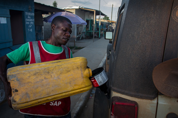
In the morning we stock up on supplies, before stopping at the bus depot/taxi place on the edge of town to ask a few drivers what lies ahead. My GPS and maps are both inadequate, neither showing a complete road in the direction we plan to go.

Passing through villages is always interesting
All the drivers agree, there is some kind of track into the DRC this way. From here to the end of Rep. Congo, and the town of Londela-Kayes, the road is pretty good, with bridges that should work and not too much mud. One guy drives it weekly, and assures me it will be no problem. There is Immigration and Customs there, so I can get stamped out of Rep. Congo.
After that is where things get interesting.
They know there is a kind of road, though none of them have ever driven it. It has some steep sections that can be horrendously slippery clay when it rains, they think. Where exactly it will spit me out in the DRC is up for debate, and nobody has any idea if I will find any kind of Immigration or Customs there. Probably I can fumble my way South to the main East-West road running along the North bank of the Congo River.
With that to go on, we drive out of town, moving South.

Three guys walking home from farming

I am happy for this bridge.. the water is DEEP
As I had been told, the road is in good shape. There are a couple of small bridges and water crossings, all similar to what I have seen before in Gabon. Once the water laps at the hood of the Jeep, though it has no problem wading through. All day the intense heat and humidity beat down, and even after applying sunscreen four times and wearing a hat for the entire day, I still get sunburnt. Progress is slow but steady, we are in no particular hurry.
The route I am taking actually parallels the border of Cabinda, and at one point I see a fork in the road and signs – it looks like I could actually go in this way if I chose.

No bridge here, water lapping at hood

Another great bridge
Late in the afternoon we pull into Londela-Kays, stopping at the Police station on the near side of town. Quickly a group of smiling kids assemble, all eager to see photos of themselves on the screen of my camera. After a short wait a Policeman enters all the details and a Customs man arrives on scooter to cancel the paperwork for the vehicles.

The welcoming party at Londela-Kays

The main street of Londela-Kays
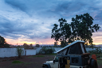
On the far side of town, we wait at Immigration for an exit stamp. All the while the sun inches closer to the horizon. Weighing up our options, and not wanting to continue in the dark, I ask and we are immediately given permission to camp right there in the Police compound on the edge of town.
For the first time in my life, I setup my camp right at the border.
I am now stamped out of Congo.
Tonight I sleep officially in no country.

Sunset over my campsite at the Police building
-Dan


Hi Dan,
Really enjoyed all your posts and photographs of the Congo leg of your trip.
However you should have posted a photograph of your team mates & their gear etc. What vehicle did they use ie was it heavier than your Jeep etc.
I am thinking of doing Africa in an Ivaco daily 4×4 with an azalai camper but am wondering if it is a little too heavy.
Anyway great stuff and glad the Congo leg of the trip worked out so well for you.
Good luck and keep us all posted!
Cheers n beers, Dave
Hey Dave,
Thanks for the feedback.
People travel West Africa in everything up to 10 ton box campers, so you’ll be fine in an Iveco daily!
-Dan
The fork you didn’t take on the road that parallels Cabinda would’ve taken you to Tshela by crossing the Shiloango river at the moukeke-kimpangala border . Dolisie to Tshela ( Dolisie-kimongo-moukeke ; you cross the river to Drc ; Kimpangala-kai mbaku-maduda-tshela).